Mourne Walks : The Slieve Muck Loop Walk
Even on days when the Mountains of Mourne seem to be overwhelmed with ramblers & hikers, yompers & footsloggers, you’ll be alone on Sliabh Muc.
The secret of the solitude you will find on this summit, is clearly in the name: Muc. A deeply wrinkled brow that scowls across the landscape, prods the curious and cautions the unwary. And presents itself as unassailable. It is not named after pigs
Description
This walk offers both a good introduction to following a route without way-marks, and the experience of crossing trackless open country. It starts and finishes on the old Banns Road, a green lane that penetrates deep into the mountain heart. On a clear day, there are plenty of features in the landscape to help you find your way.
Fitness challenges: There are no great demands as you rise progressively to the summit of Muc. Just take the time you need. But caution is required as you make the steep descent if your legs are tiring. There are a couple of less-demanding ways home for the prudent. Expect to take 5 hours plus breaks.
The Start
At a little over an hour from Belfast, or 90 minutes or so by car from Dublin, the small car-park where the B57/Moyad Road meets the Banns Road (grid ref: J 284 214) is easily found. And is a scheduled stop on the Mourne Rambler bus route. Start there.

Courtesy and copyright of Harvey Maps
The route outline
This map extract shows the general route of the walk, which you can transfer to your own map. The route outline follows an anti-clockwise direction. Two variations shown at the foot of the page, provide for less demanding descents and a third provides for a shortcut for those eager to reach the summit of Muc. You can download the Slieve Muck Loop Walk route instructions here.
This extract is supplied courtesy of Harvey Maps. It is not suitable for navigation. But links to the Harvey Map you need are given below. Please don’t walk without a map.
Advice
New to this? Then transfer the route from the illustration above to your map (or a photocopy). Finger-trace the route outline on the map. Making sure you understand the route, and what is required of you for each leg through A-C. C-D and so on.
WayFinding
There are three different, but rewarding, navigation challenges:

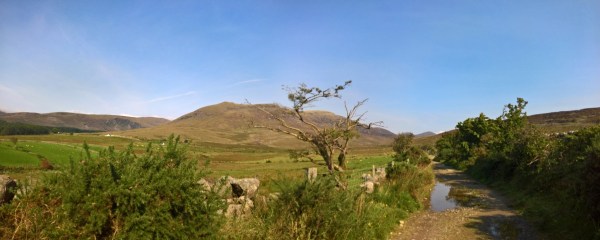
Here is your way down from Muc…
1: Finding your way from the end of the Banns Road (at Lough Shannagh) to the lower slopes of Doan to pick-up a vague tread there. It will help if you can follow a rough compass bearing.
2: Finding the steep grassy defile that will take you off the ridge and down over the brow of Muc to the upper slopes of the mountain. It will help if you can read map co-ordinates and are not in a hurry.

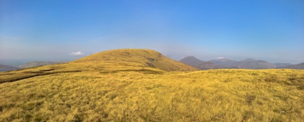
… and here’s looking back up.
3: Picking a route across the bog and the shallow depression that gathers the Yellow River, back to the Banns Road. A chance to practice working your way through open country. And you can see where you are headed in the picture above.
The Map
Best Walks review of the Harvey Maps 1;25000 scale Mourne Mountain map from their Superwalker series is on the way. The low-resolution scan used above to illustrate the route is reproduced with their permission. You can order the map online from both Amazon.co.uk and directly from Harvey Map Services Ltd.
Harvey Maps Mourne Mountains Superwalker Map from Amazon.co.uk
Harvey Maps Mourne Mountains Superwalker Map from Harvey Maps

Looking back at Lough Shannagh from below Slieve Loughshannagh
Variations and alternatives
7.2 The Walk NI route for Lough Shannagh. This is a nice variation that forms a great introduction to hill-walking. It follows the route to the summit of Carn, and then descends by the Miners Hole River. Here is the Walk NI introduction, and here is the downloadable pdf.
7.3 The Mourne Wall from Muc. Follow the route to the summit of Muc (point F), but do not cross the Mourne wall. Instead pick a route (follow a tread) roughly parallel with the Mourne Wall down the mountain directly back to point B. And go right (S) along the Banns Road back to your start.
7.4 Eager rambler’s ascent: Begin at point A. At point B go through the gate, but then leave the Banns Road and follow the route up, roughly alongside the Mourne Wall to point E.
……Careful inspection of the map and the terrain will show you that there are a variety of routes, including staying with the Banns Road a while longer, before striking out for the summit of Muc. Choose your route wisely and once away from the Banns Road, you’ll enjoy a totally trackless walk over open country.
The South Naze. Experienced mountain walkers only: There is a prominent crag on the south naze, so you must navigate to either the East or West of it. Both are possible. CAUTION: The crag is not visible as you descend from the “swine’s back” spur of the southern ridge of Muc. And you should study the terrain carefully from below (preferably with binoculars) before planning a descent that way. And take a route guided by carefully planned compass bearings as you descend. Both I and Steven Forde of MountainViews.ie have passed by this way.
The Slieve Muck Loop Walk : Looking along the broad boola
Names in the landscape
Banns : Generally reported as being from Banna (An Bhanna) meaning goddess. Personally I think it’s just a corruption of Beanna meaning: peaks.
Doan : Which you may also see written as Dhoan or Dhone is an archaic word meaning brown.
Shannagh : Also shennick, shenick are an anglicization of the Irish word sionnach or sionnaigh (fox and foxes). So the area is probably best translated as “Fox”, “Fox Lake” and “Fox Lake Hill”.
Carn : Can translate to anything from a pile of stones, to a cairn, to a rocky hill.
Boola : Another anglicization from the Irish bó meaning cow. – An upland cow pasture from the days of transhumance before the crash in population from the great starvation (Irish Famine 1845-1852). And the subsequent restructuring of land holding.
Muc : I know this word from my late Gran (and my Granddad, a bit of an Antrim man). Contacted by historians a couple of years ago they tell me she was probably one of the last native Leinster Irish speakers. Muc can be applied to any feature that resembles a wrinkled brow. I’m guessing it was originally just called Muc. The Sliabh was probably added by John O’Donovan (Seán Ó Donnabháin) when creating his Sléibhte Mughdhorn map in 1834 whilst researching place names of the first Ordnance Survey of Ireland. And to identify the feature as a mountain.
This is route 7 of Mourne Walks