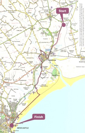
Mourne Walks : The Lecale Way – Clough to Newcastle
A rare feast, even in Northern Ireland. A countryside walk, that falls just within the boundary of the Mourne Area of Outstanding Natural Beauty. It strolls you through a landscape rich in human heritage, wildlife habitat and vistas that engage you throughout the way – at any time of year. Easy, 8 miles, 3+ hours.
Mourne Walks : Walking along The Lecale Way – Clough to Newcastle, Co. Down, Northern Ireland.
Description
This charming, mostly level walk, takes advantage of the by-gone route of a single-track railway skirting the shores of Dundrum Bay. Passes a world of heritage to visit Dundrum Castle and the quiet country lanes there. Goes on through the National Trust nature reserve and the dunes of Murlough Banks. To finish with a fine stroll along the sands of the sea-kissed littoral and onto the strand at Newcastle.
It is a one-way walk, made possible by taking a bus from Newcastle to Clough or catching a taxi for a short trip (allow £10) to the start. See the details below.
Mourne Walks : Lecale Way – Clough to Newcastle. View from the layby at the bend on the Ardilea Road
Advice
The Route Card: The card describing this route is available in a pack of over 20 walks freely available from the Tourist Office in the Newcastle Centre on Newcastle, Main Street. Titled “Make Your Day – Mourne Mountains – Walking Routes”, this is a great initiative by Newry & Mourne District Council, and I will be reviewing the pack here on Best Walks. For now you may download a pdf of the card here, to assist with your planning.

Make Your Day Walking Routes
The Start: Since the start is well away from urban bustle, do make sure you understand where you are going by reading the instructions below.
Underfoot: The route is generally easy underfoot, though a bit bouldery in one shortish field section. There is a brief portion of gently uphill/downhill as you approach and leave the high spot of Dundrum Castle. The road sections are short and not unpleasant or difficult. But you do need to cross the main A2 Dundrum Road twice, so take the usual precautions if you have children.
.
Take with you: This is one of those walks where you can dally a lot. So you might want to take food and drink. Interested in birds? Loads of ’em. Take binoculars and a bird guide. Camera and guide to wild flowers in the spring, summer and even later. Autumn, something to carry the blackberries you’ll pick along the way, whilst watching the migrating waders. Winter, wrap up warm and enjoy the frosty crunch underfoot. A camera at any time. Especially if you’ve an interest in human heritage, history and archaeology.

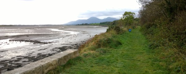
Mourne Walks : The Lecale Way – Your railway embankment route crosses Dundrum Bay
Wayfinding
Wayfinding is generally easy, as the route is well waymarked with Ulster Way and highly visible sign posts. But you will need to keep your eye on the route from time to time, to make sure you don’t miss a turning in the Dundrum area.
- The Lecale Way : From “Make Your Day”
There are a couple of spots where signs seem scarce: The field walking after Dundrum Castle. After you’ve left Moneylane Road the “right of way” is a working bohereen that seems to end with a gate in a field on your right. Ignore the gate and go straight ahead as in the picture below. At the end of the green way make a dog-leg at a junction of field boundaries (in the distance in the picture) and end up on a bouldery footpath with the field boundary on your right.
Finally: If you accidentally emerge at the Orange Hall on the Dundrum Road (instead of The Dam Lane/Derinilla Lane), you’ve missed a junction. Don’t worry the route actually continues a few hundred metres to your left (N) on the other side of the Dundrum road, opposite The Dam Lane. See the signpost picture below. The rest of the route is straight forward, but do use the map on the route card from the Tourist Office.
.

Clough to Newcastle, Co. Down, Northern Ireland. Part of the “right of way” after Moneylane Road.
Getting to Newcastle & The Start
By car & taxi: Make your way to Newcastle, Co. Down. By car it’s a little over 90 minutes from North Dublin and little over an hour from central Belfast. Park in the car-park by the seafront on Downs Road. Or at some other suitable car park in the town. The car-park adjacent to Donard Park at the south of the town (off the South Promenade) frequently has spaces.
Take a taxi to the start: Now make your way to Donard Street, where you will find a couple of taxi offices. Enquire and ask for a taxi to take you to the start of the walk here: The lay-by on the bend by Dundrum Bay on Ardilea Road, Clough. (See the picture above). I was charged £7 in October 2016 and my taxi driver found the place without difficulty. Otherwise ask to be dropped at the junction of Blackstaff Road and Ardilea Road. This is still part of the Lecale Way/Ulster Way and will be waymarked along Ardilea Road until you arrive at the bend and see your route ahead of you. (Again, see the picture above). NB. Metered charges are to be introduced for taxis and prices are expected to increase. Expect to pay £10. Alternatively you can take the bus, from Newcastle to Clough, as described below. (Map ref: 4195 3930).
By bus: If you are travelling by bus, there are Ulsterbus Services from across Northern Ireland, and particularly there are a number of different services between Newry and Newcastle if you are busing-in the from the Republic. You can visit the Ulsterbus journey planner here: http://wlk.re/UlsterbusJourneyPlanner From Newcastle to the start of your walk, you can either take the taxi, as described above. Or you can…
Take a bus to the start: Arrive at, or walk to the Newcastle Bus Station prominent on Dundrum Road/Main Street, (close by the old Railway Station and the entrance to the Slieve Donard Hotel). From there you can take one of several services (20, 26b, 240) to Clough. Alight at Clough town centre and head roughly east on the Blackstaff Road for about two-thirds of a mile until you reach the junction of Blackstaff Road and the Ardilea Road. This is the Lecale Way (Ulster Way). Follow the Ardilea Road until you arrive at the right bend and see your route ahead of you. (Map ref: 4195 3930).
You can visit the Ulsterbus journey planner here: http://wlk.re/UlsterbusJourneyPlanner
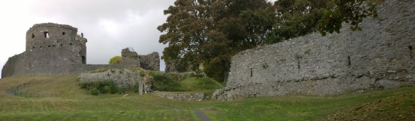
The Lecale Way: Clough to Newcastle – Dundrum Castle
Alternatives and Variations
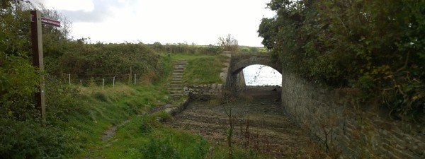
Option 1: Shorten the walk by starting from Dundrum. Walk South out of Dundrum centre on the A2 towards Newcastle. Look for the signpost directing you left, away from the road, to Murlough Nature Reserve and the Downshire Bridge (Map ref: 4015 3605). The signpost is shown in the picture below.
Option 2: Begin the walk. On arriving at Dundrum do not cross the A2, but walk into the town, to avoid the detour to the castle and inland. Instead find somewhere for a long lunch in the town and rejoin the route on the Dundrum Road as described in option 1 above.
Option 3: Take a bus or a taxi to the picnic area & car-park at the Slipperyford Bridge. Cross the road enter the track leading to the nature reserve and fork right to pick up the walk through Murlough Banks and along the littoral and strand back to Newcastle. (Map ref: 3955 3415)
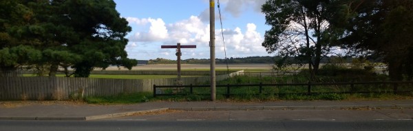
Cross or leave the A2 South of Dundrum. And follow the path by this signpost across Dundrum Bay
Language & Landscape
Being Anglo-Irish and having spent a lot of my childhood in Derbyshire, I know how they say “Clough” (as in “cluff”). And one of my favourite spots from my youth on Bleaklow is the upper reaches of Lynch Clough. But Irish spelling and pronunciation is different even in the North. And Clough is pronounced more like “Clock” even than the Scottish “lough” (lake), though you will hear both. It’s an anglicization of the Irish “cloch” and means a stone, don’t forget it.
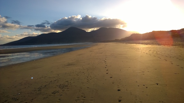
Mourne Walks : The Lecale Way – Clough to Newcastle. The final stretch of delight