Slieve Foye & The Barnavave Loop : Ireland’s Ancient East
Ireland’s Ancient East : If you are a hillwalker and a visitor, then explore a little of Ireland’s Ancient East, away from the tourist crowd. With “lost” villages, megalithic tombs and a landscape that nourished the stone age and fostered our legends.
And if you are local, but early in your hill-walking adventures, then this walk is for you. Made “challenging” only by its length (14 km), its occasional difficulty underfoot, and the need for a little wayfinding.
The Barnavave Loop : A waymarked laneway leads you through a famine deserted village
Description
Starting and finishing with well waymarked bohereen, green lanes and forestry track, the anti-clockwise route embraces delightful hill and moorland walking strewn with sights to engage and entertain.
Apart from the distance, the fitness challenges are: The initial climb (on minor roadway), picking your way through the boulders and bog as you rise up and contour around the gabbro summit of Slieve Foy, (just take your time, it’s worth it). And the descent of Slieve Barnavave, (respect your knees). Practice your wayfinding and be prepared for days when the winds blow up from the Irish Sea and over the ridge of Slieve Barnavave. And if it’s too much, there is a shortcut halfway around.
There are route instructions on Discover Ireland and from Carlingford tourist office (details and links below). OSI 1:50,000 Discovery Map no 36.
Getting to Carlingford
Since the building of the motorways the Cooley Mountains are now little more than an hour from either Dublin or Belfast, and Carlingford itself not much more than 90 minutes away. There is plenty of car-parking with no shortage of hotel or B&B accommodation. And there are overnight camper-van facilities at the Carlingford Marina.
Bus Éireann also runs the 161 service from Dundalk to Newry, via Greenore, Carlingford and Omeath. Check the timetables here www.buseireann.ie
And if you are rambling on a budget, there is an approved campsite at Gyles Quay, that is some distance away, but it is on the bus route. On the plus side, Carlingford Adventure Centre have approved hostel accommodation.
Cooley Peninsula Tourism +353 42 9373033: If you are planning on a trip you’ll find the staff at the office in Carlingford very helpful. And the old railway station office is easy to find, open 7 days a week, has a really useful range of books and maps of the area; and that includes local walk guides for the routes listed below, available for about €1 each.
Advice
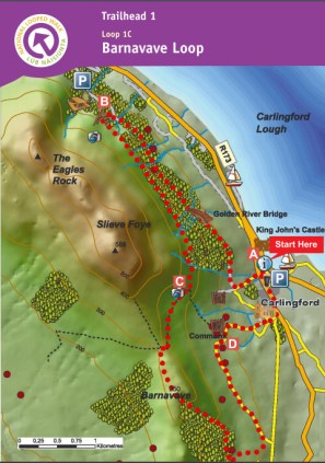
Download this Barnavave Loop route map . Read about the walk and copy/print off the route instructions from Discover Ireland here.
Caution: The map is there to help you identify the route on the ground. It is NOT a substitute for a map from the Ordnance Survey of Ireland or similar. Click here to go the OSI shop page for the map you need.
Shortcut: By the time you reach the path junction at point C, you’ll know if you are up for the rest of the walk. If you decide to be prudent, you can turn left at C and follow the blue way marks downhill directly to point D and The Commons, turn left onto the road, and pick up the Barnavave Loop from there back into Carlingford. And come back for the Barnavave summit another day. (See below).
Important: Notice re the route instructions
The main text for the route instructions is currently unavailable whilst it is being re-written. In the meantime, if you’d like a set of route instructions, drop me a line here, I should be able to furnish you with a copy of those supplied by the Carlingford tourist office.
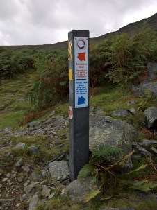
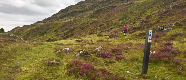
This waymark shows the fork in the route at point C
WayFinding
This is a waymarked walk and the photo shows you the kind of waymarks used once out of Carlingford. You’ll spot them easily enough, most of the time. Just know you are following the red arrows (not the UK flying team). The remaining green and blue arrows, and the yellow walker, apply to two other local routes (see variations below) and the much longer Táin Trail.
Waymarks: Tall bracken can hide the posts, young horses can push them over. But they are regularly maintained so if you fail to spot any, check your route. The most obvious location is the summit of Barnavave (image below) as the waymarked route doesn’t actually run over the summit but along the slopes to the south. So do familiarise yourself with the route on a map. And at the start, orient your map with the terrain, and try to visualize the route on the landscape. If you are completely new to wayfinding, here is a post that will help you use a compass or smart-phone, to find north: Using a Compass: Finding North. Then find the compass rose on your map. And then rotate your map so that the compass rose on it, also points north.
It might be worth noting that the forestry running down the naze (nose) of Barnavave has now been harvest and replanted so you will see open terrain across to your right when descending the Barnavave naze and not dense forestry as the map might suggest.
Alternatives & Variations
Starting at the same trailhead (as Discover Ireland names them) there are three other waymarked looped walks with route instructions and downloadable maps:
Slieve Foye Loop (Blue waymarks)
……Read and copy the route instructions
……Download and print the map
This follows the same route as the Barnavave Loop until it reaches point C, from where it becomes your shortcut route. Follow the blue waymarks to take you back to Carlingford, without ascending Slieve Barnavave.Commons Loop (Green waymarks)
……Read and copy the route instructions
……Download and print the mapMolly Loop
……Read and copy the route instructions
……Download and print the map
Just Slieve Barnavave
If you think you can work it out. From Carlingford, follow the Slieve Foye Loop backwards/clockwise (blue waymarks) via point D in The Commons to point C on the slopes of Slieve Foye and The Barnavave Loop. Once there, at the waymark illustrated above, follow the red waymarks for the remainder of the Barnavave Loop, which will eventually bring you back to point D in The Commons and on back to Carlingford. It’s generally quite easy underfoot.
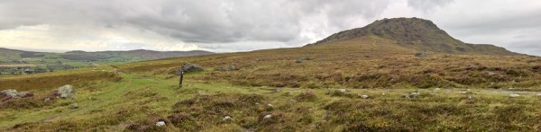
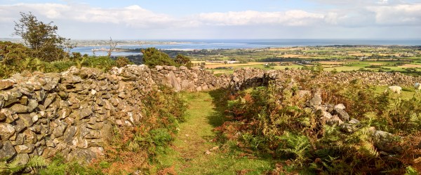
On the saddle between Slieve Foye and Barnavave. Your route goes to the bottom left of the picture
The Summit of Slieve Foy & more of the Cooley Mountains
You can see from the Discover Ireland map, that once you’ve arrived at point B, then by taking a bearing roughly south and up the mountain side, you can make your way into a convenient saddle on the ridge. From there you head south-south-west to the summit of Slieve Foy and having paused to enjoy the outstanding panorama, can continue on roughly in the same direction down the face of the slieve to regain the route of the loop walk in the saddle between Slieves Foy and Barnavave. In which case you might enjoy walking the whole route in reverse (clockwise direction). I hope to describe the route sometime before the end of the year.
That should give you a taste for more in the Cooley Mountains and I’ll try to add additional routes during 2017.
The Barnavave Loop : Contouring the slopes of Slieve Foye – Don’t be path-bound.
End